Walking Locus Plus
Walking Locus Plus Description
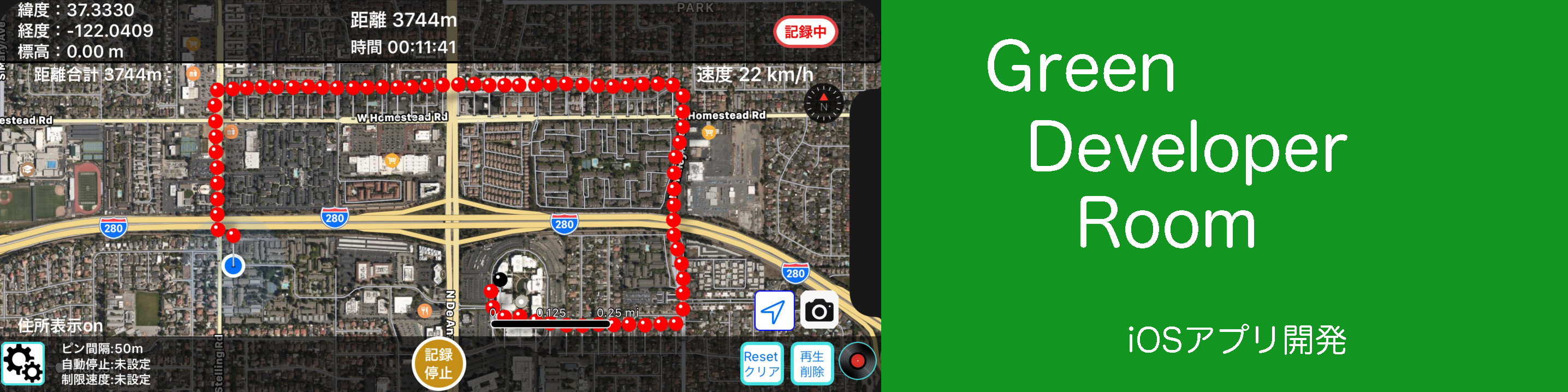
You can save the walk (walking distance), movement (route, distance, time) on a daily basis and play back later.
You can check the route you walked when walking in an unfamiliar street and the point where you are.
● Description of the application
It is an application that displays the movement locus using GPS.
Record the point where you walked with a pin, and move at the set distance interval, Display the latitude / longitude and distance from the recording start point of each location on the top of the screen.
When you click on an arbitrary pin, the time at the point passing and the distance from the recording start point are displayed as pin information.
Unlike a pedometer, the distance between moving points represents the distance between GPS points, and the moving distance within the setting interval is not counted.
Also, depending on the location, such as inside the house or in the tunnel, you may not be able to update the pin if you can not detect the GPS, but the distance measurement is automatically restarted from where you caught the GPS again, so the distance is displayed almost exactly .
● Function and operation
The functions and actions of the main buttons are as follows.
·「STL/Map」 Map type setting button
You can switch between standard map and satellite map.
· 「Rec/Stop」Record / stop button
Tap the "Record / Stop" button to start location information service and tap again to stop location information service.
The first zero distance pins are displayed in green.
If you are not using this application, please stop to prevent battery drain.
· 「Intv50m」Pin recording interval setting button
Pins are displayed at distance of 50 m, 100 m, 200 m, 500 m.
It is also possible to record the pin recording interval in hours, 30 seconds, 1 minute intervals.
· 「Timer /NoSet」Timer setting button
After recording starts 1H, 2H can be set and recorded to prevent forgetting to push the recording stop button.
This stops the recording automatically after the set time to prevent battery drain.
・「Meter/Clear」Distance clear button
Clear the distance meter to your current location (red pin) and set it to 0m. Also start distance measurement from that point.
It helps to measure distance between points.
· 「PlyB/Del」History play / delete button
Select the day and play back the previous record and delete the record on a daily basis.
If "all" is selected, all the data up to now will be deleted.
· 「Record mark」Save data list display button
Displays a list of saved days and dates.
· Location registration
If you press and hold the point you want to register on the map, you can register the name you want to attach to the pin. Pins are displayed in blue.
Click on that pin and press the 「Way」 button to show directions from your current location on the Apple Map.
Please click 「WalkRecord」 that was displayed small in the upper left when returning.
If you press 「Del」, this pin will be deleted.
· Latitude longitude label
The latitude and longitude of the current position (pin position) is displayed at the top of the screen.
Also displays the distance between the current point and the previous point and , and the total distance from the recording start point.
・Elapsed time label
The elapsed time during recording is displayed on the upper right of the screen.
** Please install on iphone or iPad and turn on the application and actually walk and check the operation.